
Hiking Cape Brett Walkway
Hiking Cape Brett walkway, a spectacular, but challenging hike in northeastern New Zealand, offers stunning views of the Bay of Islands, a secluded cove for swimming, and a hut at the end overlooking a lighthouse and giant rocks in the sea.
At the end of the Peninsula, and the end of the trail, you will find picturesque rock formations in the ocean and panoramic views of the area. A fantastic area to explore after checking into your hut at the end of the hike.
As this hike is pretty remote, it’s not a popular tourist hike. Because of this, you will not only be miles from the nearest town, you will likely have the whole place to yourself, as I did.
And although I whole-heartedly admit that I was nervous when I realized just how remote it was, everything turned out fine. In fact, I found the challenges, and remoteness made the hike, and the view, that much more spectacular.

Hiking Cape Brett Walkway
The trail starts at Oke Bay in Rawhiti. It follows the peninsula out into the Pacific.
The full trail is a little over 10 miles (16.3 km), with the last half being the most challenging. Expect the hike to take about 8 hours, one way, for the average (experienced) hiker.
Alternatively, you can start the hike at Deep Water Cove, instead of Oke Bay. As this is a little more than halfway, it shortens the hike to about 4 miles (6 km).
Although shorter, the trail from here to the hut is the steepest. It also provides the most spectacular views. It will take 2-3 hours.
Oke Bay To Deep Water Cove
The trail from Oke Bay to Deep Water Cove is about 6 miles (10 km).

This portion of the trail runs through Maori-owned land.

It is a lovely wooded walk with occasional glimpses of the Bay of Islands and coast along the way.

Deep Water Cove
Deep water cove is a charming spot along the trail. There’s a side trail that heads down to it, where you can rest and swim for a bit. It’s about 30 minutes each way. Or, if you want, hit it on the return trip (like I did), when you know you have the time.
Actually, unless you really want to go hiking along all 10 miles of Cape Brett Walkway, I suggest starting and ending your hike here. To start from here, however, you need to arrive via water taxi.

As I departed from here the day after my hike (I pre-arranged a water taxi to pick me up), I arrived early for a swim. It was simply stunning! Especially since no one else was around.
It was like having my own private beach. Making it even more special, there was a stingray swimming with me! I have read that it’s also common to see dolphin and/or seals here.
On my hike down to the cove, I ran into a couple, the only other people I saw on the entire hike. I assume the boat and dingy at the cove above was theirs as I didn’t see anyone else.
One thing I learned about this area is that the weather can change very quickly. About an hour or two after I took the photo above, a dark storm started rolling in. Thankfully, my water taxi driver was aware of it and came to get me early. Those kiwis really are amazing people!
Deep Water Cove To The Lighthouse
This is the steepest, but also the most beautiful part of the hike. It’s about 4 miles (6 km) and takes 2-3 hours.

Although some of this trail is also in wooded areas, much of the last part of the hike is in full sunlight, so it can get quite warm.
At times the trail comes close to the edge, where you can see the waves crashing below. Simply stunning.

As you rise in elevation, the views start to become even more spectacular. The best is when you finally crest the peak of the Peninsula.
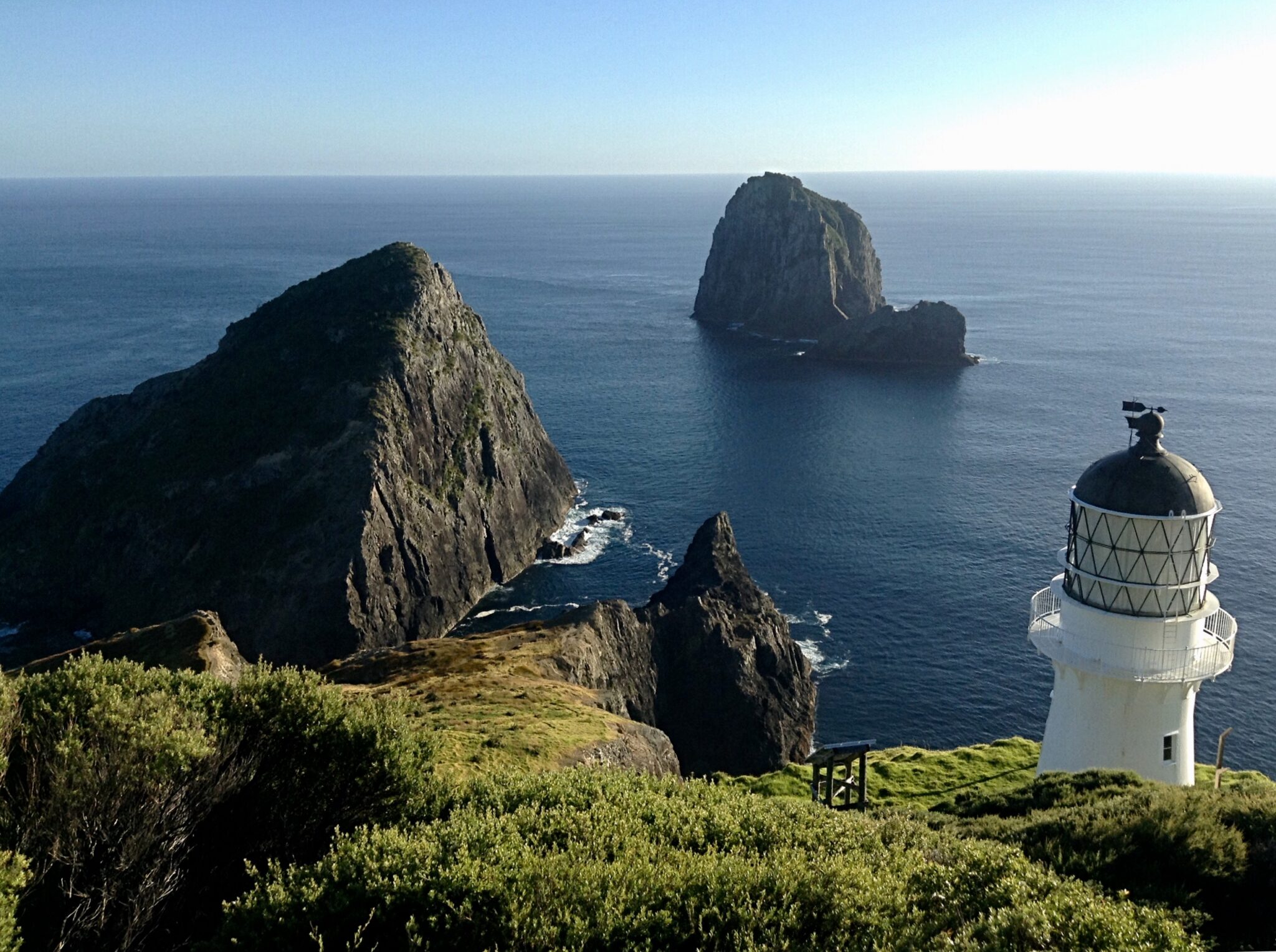
Here, you will see Cape Brett lighthouse (above) and the lighthouse keeper’s hut (orange roof below), along with the beautiful cliff formations in the Pacific.

As camping is not allowed here, you must pre-arrange an overnight stay in the Lightkeeper’s hut. Although it looks tiny in the photo above, it sleeps 23 people. Yes, the rock formations in the ocean really are big.
The Lighthouse Keeper’s Hut
The hut is maintained by the New Zealand Department of Conservation. It’s a charming, old wooden hut with 23 bunks beds arranged in multiple rooms. You need to bring your own sleeping bag and pillow for the wooden bunk.
There are also gas stoves, a water supply, and pit toilets outdoors. Note that sometimes in the summer, the water source dries up and no water is available, so always carry your own water anyway. If water is available, it is advised to boil it before drinking. You can also bring water treatment tools.
In addition to this, although there are gas stoves, as I was the only person in the hut, I was not able to turn the knob outside to get gas to the hut. The previous person must have shut it super tight and I just didn’t have the strength. LOL
Thankfully, I had enough food that didn’t need heating for one night. Because of this, and a variety of other issues that could arise, it’s also advisable to have food with you, along with enough water, that doesn’t require cooking.
A picnic table sits above the cliffs, by the hut, for a beautiful place to eat and watch the sunset.

Booking The Lightkeeper’s Hut
The hut must be booked in advance on Doc.govt.nz. Although this hike is not as popular as the Tongariro, Routeburn, or Milford Sound hikes, it’s still best to book far in advance.
Once you make your booking, you will be sent a code for unlocking the door. When I was here, I was the only person in the hut, so don’t forget the code!
Hut Costs
The hut is $25 for adults and $12.50 for children as of September 2023.
Tramping Permit
If you start from Rawhiti, there is also a $40 tramping (hiking) permit per person (for crossing the Maori-owned land). The fee is to provide funds for maintaining this part of the trail. It’s $20 for children.
It can be purchased on the website when booking the hut. Make sure you carry a copy when you hike, so you’re not fined or double charged.
This permit is not required if you start/end at Deep Water Cove, as then you don’t cross the Maori-owned land.
How To Get Cape Brett Walkway for Hiking
Driving
The beginning of Cape Brett walkway is in Oke Bay, Rawhiti, which is about 18 miles (30 km) northeast of Russel. You can drive there via Rawhiti Road. Detailed driving directions, as well as where to park your car, can be found on doc.govt.nz.
If arriving from Paihia, there’s a regular ferry to Russel, that also carries vehicles.
Water Taxi
You can also take a water taxi from Russel or Paihia, to either Oke Bay, or, Deep Water Cove. I opted for the water taxi from Paihia to Oke Bay. For the return trip to Paihia, I pre-arranged pick up at Deep Water Cove.
The water taxi from Paihia was about 45 minutes to an hour. Although long, and expensive, it’s spectacular way to see some of the 144 islands here. We had the extra bonus of a pod of dolphins swimming beside us for a while.
If arranging a water taxi, I suggest doing so in advance. I did not realize how remote this area was. This meant I was only passenger, which made my ride really expensive, but still totally worth it!
Dive Ops is the company I used, and they were fantastic. Extra points go to McLella who arrived early to pick me up as a storm was rolling in!

Summary
If you’re really fit, you like a challenging hike, and don’t mind the remoteness of this area, I highly recommend hiking Cape Brett Walkway. In fact, its remoteness makes it more magnificent (at least to me).
Just keep in mind, that since it’s remote, and you may not see another person on the trail, you need to be an experienced hiker. Carry enough food and water with you, as well as emergency supplies.
For other great hikes in New Zealand, see my posts on Routeburn Track, Abel Tasman Coastal Track, and Tongariro. These are all on the list of New Zealand’s 10 “Great Walks”.
If you’re visiting the South Island, you can’t miss stunning Queenstown, the capital of adventure, Milford Sound, one of the most visited places in New Zealand, charming, mountainous Wanaka, or Franz Josef Glacier.
To help plan your trip, check out my New Zealand Travel Guide, to learn more about the top destinations, how to get around, when to visit, safety tips, and more.
Julie
Hello! I resigned from a corporate career in product development to explore the world. Although my goal was to travel for a year, 8 years later, I’ve been honored to have explored more than 60 gorgeous countries and met some unbelievably amazing people. Our world truly is a beautiful place! Follow me into the gorgeous unknown by subscribing below. You’ll receive details on fabulous destinations, comprehensive travel guides, travel tips and tidbits, and information on travel trends, like experiential, sustainable, and transformational travel. Where is your next gorgeous unknown? Julie


You May Also Like

Visiting Fairy Tale Canyon (Skazka), Kyrgyzstan

Exploring Enchanting Myrtos Beach & It’s Stunning Viewpoint
